
The view from the 'groundwatershed'
Plus: A California town is looking at a $800/month rate hike, the release of a National Water Strategy, the MORE WATER Act, and other headlines.

Our maps often reflect the surface of our Earth. Shades of bright blue, deep green, and sandy beige. Blue polygons for lakes and oceans. Blue lines for rivers and streams. The markers of our water sources — but not all of them. Groundwater, what we don’t see on many maps, accounts for 50% of domestic use and 40% of irrigation use globally.
And yet it’s so often “out of sight, out of mind.”
Those numbers come from a recent UN report declaring that we are living in an era of Global Water Bankruptcy and must move beyond temporary “crisis” responses to longer-term management that seeks “to prevent further irreversible damage, rebalance rights and claims within degraded carrying capacities, transform water-intensive sectors and development models, and support just transitions for those most affected.”
At the center of these challenges often lies a groundwater story. And sometimes it helps to see it to believe it. Exhibit A: The photo below is used in the UN report and captioned “The Visible Face of Water Bankruptcy.” It shows a sinkhole in Turkey, a “direct result of extracting groundwater much faster than nature can replenish it.”
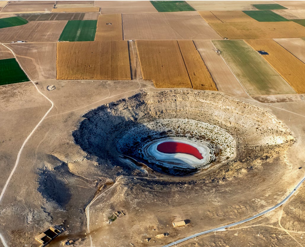
It’s an important visual to take in.
Reports like this can, should and do, make groundwater more visible. But making groundwater more visible, and less hidden, is easier said than done. What language is there for us to use? What visuals should we use to illustrate its full spatial extent?
Where does the groundwater flow and where does the water go?
I’ve been thinking about this a lot over the past couple of months.
Zooming In and Out
Groundwater is difficult to describe or visualize, despite being such a key part of the water cycle, a node that supports rivers, wetlands, springs, and ecologies that, in turn, supports communities who rely on it for drinking water and growing food. Part of the descriptive challenge is that aquifers can be geologically specific, highly-complex, and localized, requiring you to Zoom In to many different places to understand the whole. They are also dynamic systems, influenced by human actions and natural variability.
Zooming In is important, but it often leaves us with so many technical details we get lost in the weeds. Like calibrating a microscope at its highest magnification, we can forget the ways in which the parts are integrated with the whole. After all, individual groundwater aquifers connect to rivers and ecosystems in varied and changing ways.
So we Zoom Out.
Zooming Out matters because groundwater can flow over time and over long spatial extents (consider Nevada’s Lower White River Flow System, a “superbasin” of seven distinct hydrographic basins connected by groundwater). It’s important to visualize groundwater as more than a point (a well or a spring) on a map, but in its full extent.
Still, when we (I) Zoom Out too far, we (I) often lose the groundwater piece altogether as we (I) tend to revert to the surface features we can see. Here, I’m thinking about some recent newsletter-ing on the Colorado River. We go back to the watershed-scale, in which groundwater is a major component, but so often not centered in discussions.
Where do we calibrate then? Do we have language for something in between?
A ‘springshed?’ A ‘groundwatershed?’
A couple months ago, a colleague texted me about a project mapping the sources of springs in the northern part of the Great Basin. The text included a word I’d rarely seen before. A “springshed.” Something clicked. A play on a “watershed,” it was an intuitive term to describe the spatial extent of groundwater’s contribution to springs.
Keep reading with a 7-day free trial
Subscribe to Invisible Waters to keep reading this post and get 7 days of free access to the full post archives.